


Update, Aug 2017
Sergeant
Kennedy was the officer in charge of the Mansfield party to hunt for the
Kelly brothers. Following the fatal shootout with Ned Kelly at
Stringybark Ck where two police were killed, the Sergeants body was not
found till five days later about 800 yards down the creek north. The exact spot was
never marked. The quest to find that conclusive spot is now more complete.
14
March 2014,
Leo Kennedy asks Bill to help him locate Sergeant Kennedy's murder site.
In 2014, I was asked by Leo Kennedy if I could help locate the likely spot where his great grandfather Michael Kennedy was killed by Ned Kelly.
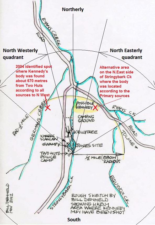
In 2002, I identified the correct site of the police camp known as the
Two Huts site.
This therefore was the only logical starting point in the search for the
Kennedy site.
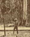
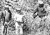
After a careful reading of primary sources and analysis of the 1878 Burman photo taken at the site where Sergeant Kennedy’s body was found, I set out with Leo along the east bank of Stringybark Creek in search of the site.
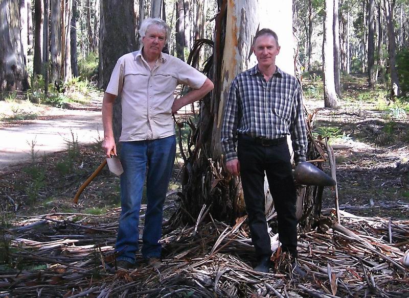
Bill
(left) with Leo at SBC ready to explore every nook and cranny along the
creek.
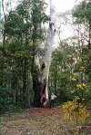
After several days of bush bashing and measuring distances, we were able
to eliminate a dozen sites along the creek. Eventually we determined
that only one site was consistent with the Burman photograph and written
descriptions. The site is located some
850 metres
away from the Police Camp site where Constables Lonigan and Scanlon were
killed. The photograph below shows Leo Kennedy at the site in front of
a tree that I consider is likely to be the same tree which features in
the Burman photo (see below).

Click on above image to enlarge.
We initially decided not to publicize our findings in the hope that a proper archaeological investigation could be undertaken of the identified area. In this regard, it is likely that the shot that passed through the sergeant’s body would still be embedded in the ground and that a proper archaeological investigation could pinpoint the exact location.
However in 2015 Leo and I accompanied journalist Lisa Clausen to the site as part of Leo’s quest for proper acknowledgement to be given to the three policemen killed at SBC. This resulted in a feature article “The true history of the Kelly victims” being published as a feature article in The Age newspaper on 11 April 2015. It was hoped as a result of this article that this would lead to the site being properly investigated and identified and ultimately signposted.
Following the publication of 'The Age' article, we were contacted by Gene-pool, a film production company which was interested in taking on the Kennedy /SBC story. Unfortunately as much as I would like to have been involved in this documentary given my vast knowledge and experience of SBC, Gene-pool wanted to use the TV archaeologist Adam Ford as the SBC “expert” for the purpose of the documentary.
I understand, but hope I am wrong, that Gene-pool have also consulted with and possibly been influenced by a group which calls itself CSI@SBC (i.e. Crime Scene Investigation @ SBC) which claims to have identified another site as the site where the police were camped and where Lonigan and Scanlon were killed. The fact that this site is totally wrong can be easily proven, because photos of the camp was taken looking Southerly where as the CSI group requires the photo to be facing North East . Refer to my explanation - Two Hut site - PDF doc
It seems to me that the Gene-pool documentary may well identify the site
of Kennedy’s killing based on the work I undertook for Leo Kennedy.
Hopefully my work in identifying this site will be properly
acknowledged. It seems to me however that if the site of the Police
Camp is not correctly identified, then this will make the documentary
historically inaccurate. It would be unfortunate on the one hand to
correctly identify the site of Kennedy’s killing, whilst at the same
time incorrectly identifying the site at which Lonigan and Scanlon were
killed.
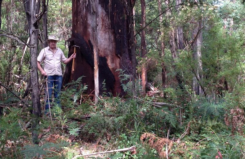
Below: Bill stands by a most likely
tree as in the Burman photo of 1878/9 as we believe this is the same area.
Updated, 14 Dec 2012
Where did Sergeant Kennedy die ?
Was it along STRINGY-BARK or GERMANS CREEK ?
Sergeant
Kennedy was the officer in charge of the Mansfield party to hunt for the
Kelly brothers. Following the fatal shootout with Ned Kelly at
Stringybark Ck where two police were killed, the Sergeants body was not
found till five days later about 800 yards down the creek north. The exact spot was
never marked. The quest to find that conclusive spot is not complete.
One may well ask why it is important to identify this site? With a major
monument in honour for the three fallen police in the centre of
Mansfield town, isn't it rather sad that nobody bothered to mark the
actual sites where those events happened so long ago? While Constables Lonigan and Scanlan's
tragic fate was at Stringybark Creek, Sergeant Kennedy is synonymous by
all contemporary accounts with German's creek,
and not Stringy Bark Ck, (SBC) but is that correct ?. It is important to identify the true historic sites, -
if only in pursuit of truth and knowledge.
On 28 August 2004 and leading up to that time a small group ventured to
locate the true site along Germans Creek, given that we accepted the site of
the police camp 'bailup shooting' site was on the Eastern bank of SBC. We were, Tim Smith, Joe Dipisa,
Bruce Johnson,
myself and a few others.
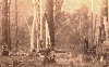
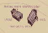
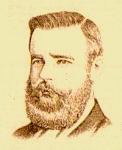
Image below from
"Pictorial History of Bushrangers, Paul Hamlyn 1966
Original image
held by Victorian Police Museum - Historical Unit. Melbourne.
 |
 |
The evidence. From careful examination, both these pictures have
flat ground and gentle rising slope in the background, Both pictures have
a ' light 'source from the left, indicating North. In the left picture, the trees are over
exposed with light offering little shadow detail. However, the cloak over
the body on the ground gives strong indications where the light source is
a midday sun in a November's Northern sky. Note; the folds in left man's
trousers, the light falling on his back show the light source coming
from above left.
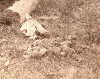
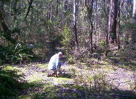
Picture above right. Researcher Tim Smith in a open natural clearing, examines
a photo copy and notes - the
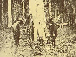
similarities of the terrain. The original image (above left) was a
re-enactment by FC Burman, (taken around the same time as the SBC police
camp photo where Constable Lonigan was shot dead), and shows the
actual tree near where the Sergeants body was found. It was reported
the tree was between the body and the police camp (some 30 chains to
1/2 Mile North). If we analyse the light we can conclude, the scene depicted is the Eastern bank of
a creek looking East, but if the tree was between the body and the
camp, then the photo must be looking south westerly and the light coming from
an eastern morning sun.
Although
photo (right), shows a clear opening on the east bank of a Creek, this
site was first selected following descriptive texts as this article will
consider.
Some considerations;
In contemporary
Kelly publications, we read that -
the Sergeant's body was
found on the other side of the Creek from their encampment ( McIntyre),
this supports Kelly author Ian Jones who has the police camp on
the Eastern bank of Stringybark Creek, The problem for Jones, if the body was
found on the other side of the creek to the west and photographed looking
EAST according to sunlight observed, then the North west is in close proximity
to German's Creek and this is where the first search was focused. But nowhere in the Primary Sources does it say the body was found near
German's Creek !
This then leads us to consider the police camp was actually on the west
bank at the site of the two huts site and makes sense that " the body
was found on the other side of the creek" on the east bank of SBC and
not Germans Ck at all.
Primary sources -
Recorded at the time of finding the
sergeants body;
Constable McIntyre's Manuscript Page37 quotes a telegram by
Sub Inspector Pewtress within one week of the killings, 31 Oct
1878 ; "At 8 a.m. the body of Kennedy was
found about a mile North East of the camp by one of the
volunteers named Henry Sparrow the overseer of Mount Battery Station.
Meaning Stringybark Creek.
( this fits with the two huts site)
McIntyre Manuscript Page 37-
The body of Sergeant Kennedy had been found 8 o'clock that morning in
the midst of some ferns over a quarter of a mile down the
creek from the site of our encampment. (
this fits with the two huts site)
It is important to note the description of the
site, Pewtress wrote
"in the midst of some ferns".
G.W.Hall wrote;
30 chains ( = 660 yards). Hall actually visited the site
and was the special Mansfield reporter - for the Melbourne Herald
5/11/1878. (
ten days after )
The Mansfield Gaurdian, Saturday 2 Nov 1878 only eight days later
- reported
" The body was found about a quarter of a
mile from the spot where the Police were camped, with his cloak
thrown over him " -- He
(Kennedy) was making his escape in the same
direction that M'Intyre had taken " .
Mounted Constable Thomas Orr stated
" on arrival at the
(police) camp
the party scattered about to search in a North
Easterly (crossed out and rewrote)
westerly
direction.
Here we have Const Orr stating the search started in a westerly
direction.
When the body had been found several of the search party were to
make sworn depositions-.
First was Henry Sparrow who said the search proceeded
in a North Westerly direction when
he discovered Kennedy's body.
"At
about a quarter of a mile from the camp I discovered the body of
Sergeant Kennedy, he was dead & lying on his back with a police cloak
spread over his head and body. The spot was open for eight yards
round about."
This may mean the search started N West of the camp but that Sparrow
ventured over SBC to the Eastern bank and came across the body of Kennedy. This works when we read that McIntyre escaped on Kennedy's
horse heading North, - tracks that Kennedy followed.
Constable James who with the help of Black Trackers found the Kelly camp
one month later, he said from the police camp they followed horse tracks
crossing the creek - swampy ground north of the police camp that
eventually led to the
Kelly camp some 1 - 1/2 mile North West of police camp.
James Tomkins,
President of the Mansfield Shire Council -
The Primary source
includes a Telegram Tomkins sent to Sub Inspector Pewtress-
Telegram
31st October
1878.-
“ To the Chief Commissioner of Police. - Since my report to you on Monday night, I organised a party of 11 volunteers and 6 constables. Started on Tuesday morning for the Stringybark Creek, and searched for Kennedy until dark without success. We returned to Mansfield at midnight. I got together another party of 16 volunteers yesterday afternoon, and with 5 constable's proceeded to Monks hut. Stopped their all night, and started for Stringybark Creek this morning at daybreak we arrived there at half past 7 AM and immediately renewed the search at 8 AM the body of Sgt Kennedy was found about half a mile and north-east of the camp by one of the volunteers and named Henry Sparrow, an overseer at the Mount Battery Station”
The body of Sergeant Kennedy
was found on the East side of SBC, and a large tree has been
identified by myself with Leo Kennedy as the most likely spot in
accordance with the Burman Photo.
What does
this tell us? Two men, Sparrow and Orr -
say they started the search in a North Westerly direction from the police camp,
when Sparrow came across the body of Kennedy.
Three men, McIntyre, Pewtress and Tomkins accept the body was found North or North East
of the camp.
( this fits with the two huts site on the west bank)
It should be mentioned that McIntyre said Kennedy's body was found North
of their encampment - meaning Stringy Bark Creek. He also said Kennedy's
body was found on the other side of the Stringy Bark Creek (SBC) from where Scanlan
was shot and fell ). Currently, we have re considered the Police camp was in fact on the
Western bank of SBC at the site of the TWO
HUTS some 200 metres SOUTH of the Kelly tree.
We also now have a good idea where Scanlan was shot in relation to
the two huts site.
It now starts to makes sense that Sergeant Kennedy's
body was found North EAST along Stringybark Creek and not Germans Creek
at all.
So, by all this we have not yet properly identified Sergeant
Kennedy's site of death?
It is important to note the description of the site,
Pewtress wrote
" in the
midst of some ferns "
Sparrow wrote -
" The spot was open for eight yards round about."
____________________________________________
Some background and recent analysis
on forums-
I table the following explanation
|
Around August
2010, KC2000 forum had a thread posted - ' Location of Kennedy's body at
German Creek' - started by Kenny T -
http://kellycountry2000.forumco.com/topic.asp?TOPIC_ID=1006
In this short lived
forum topic debate,
KennyT proposes the
finding of Kennedy's death spot has great bearing on the true location
of the Police camp.
|
In response to Kelvyn Gills group I post the
following article that was on the NK Forum, but was deleted -
|
|
___________________________________
The following
information was our
search along Germans Creek
in
2004,
but this is not conclusive if we take all the evidence into account.
What we are looking for is a relatively flat bit of ground as shown in
images below.
We don't believe much would have changed here in the past 134 years.
( as of
2012)
Below,
Tim Smith considers this site on the eastern bank of Germans Creek, and by all descriptions the
clear area is typical of the area we are looking for.
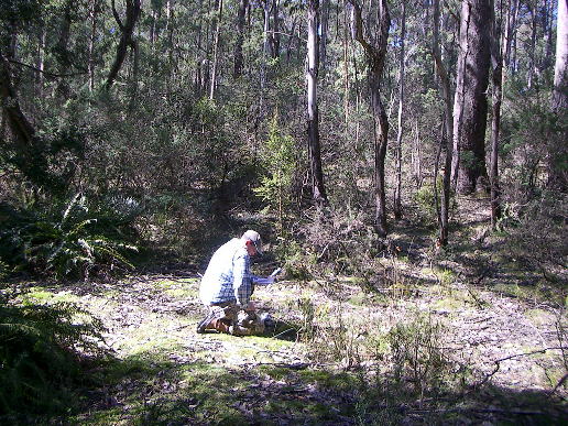
Note; this
clearing fits all criteria. It is 8 yards round about, in the midst of some ferns even
today.
Following is a record of most ( if not all) references to the finding of
Sergeant Kennedy's body circa 1878 including recent publications.
From the
secondary sources
-
records of later
publications,
a guide to where the body of Sergeant Kennedy may have been found ;
Outlaws of the Wombat ranges by- G. Wilson Hall, 1879
Page 32 SLoV* transcript, or ( Page 29 Brian McDonald's edition)- Outlaws--
G.W.Hall wrote;
30 chains ( = 660 yards). Hall actually visited the site.
Page 35 SLoV* transcript, or ( Page 31 of
Brian McDonald's
publication of Hall) -, headed due west. It also
says Kennedy followed similar route but at a slightly different angle. (
May mean North first then due west as Mc said)
* State Library of Victoria.
In McIntyre's Manuscript – courtesy Police Historical Unit -
24 years after the event
Mc say's he, jumped on Kennedy's horse he
headed North. He also said he headed
due west.
Page 37 telegram by
Henry Pewtress wrote -
the body was found about a mile North East by a
volunteer Henry Sparrow.
On the same page - The body
had been found 8 Am in the midst of some ferns over a 1/4 mile down the
creek from the site of our encampment.
( Meaning SBC)
J.J. Kenneally, Inner History of the Kelly Gang 1929 -Page 59 "
a farmer Tomkins crossing the 'Stringybark' came across the Kennedy's body
a quarter of a mile from where McIntyre
had sworn he had surrendered "
NOTE:
Tomkins
was the President of Mansfield Shire, not a farmer.
Book, Colonial doctor and his town, by J Gillison 1974 states the son of doctor
Samuel Reynolds- Willy Reynolds being in the search party states
-body found 400 yards from the camp.
Keith Mc Menomy's 1984 book says,-
" the body just North* of German’s Ck- about a quarter of a mile North
West. The spot was open for about 8 yards around about. We had not gone 30
chains when a young man Sparrow sang out - Here is something, here it is".
*The 2001 edition only says North west.
Ian Jones writes; in 'A Short Life', Page 137 and 2nd
edition Page 122,
" Ned crossed German's Ck and
started up the flank of its gully".
___________________________________________________________________
Here are some scales
1/4 Mile =
440
yards is about 403 meters - McIntyre, McMenomy book, JJ
Kenneally book
1/2 Mile = 880 yards is about 806 metres Tomkins
1 Mile = 1760 yards is about 1612 metres Pewtress
30 chains = 660 yards 604 Metres. This is more than 1/3 but less than 1/2 mile.
McMenomy
Contradictions ; McIntyre's Manuscript is rather contradictory as
it infers the body was found on Stringybark as he writes;
a 1/4 mile down the creek from the site of our
encampment. This
means the body was found on Stringybark Ck? Even the telegram by Henry Pewtress
tells us a mile North East ?
This MAYBE CORRECT ? I believe this is correct
In J.J. Kenneally's book, P 59 farmer Tomkins
"crossing Stringybark Creek came across Kennedy's body a quarter mile from
where McIntyre had sworn he had surrendered".
As co writer of J.J.K's book, Tom Lloyd would have known the true
location where Kennedy's body was found.
Conclusions ;
In all the original texts nowhere does it say
crossing German’s creek. Nowhere in any of the original text does it say
the body was found on the other side of German’s Creek except in Ian
Jones and in Keith McMenomy’s books.
In J.J Kenneally’s book The Inner History of the Kelly Gang, refers to
crossing Stringybark Ck. before finding the body. This again supports
searching N.East if
the police camp was on the Western side of SBC.
Some may conclude Sergeant Kennedy's body was found at German's Creek
because McIntyre claimed Kennedy followed his direction of escape - due
west, he also said North, perhaps meaning he headed due west after first
heading North.
Ned Kelly's account, - Dan went to the creek to get
some water for the Sergeant to drink. In our scenario, the creek would
have been immediately behind where the Burman / Kennedy photograph was taken.
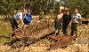
Picture below, 23 October 2004,
almost 126 years after the fatal police shootings, a party of Kelly researchers gathered at StringyBark
reserve for a guided walk.
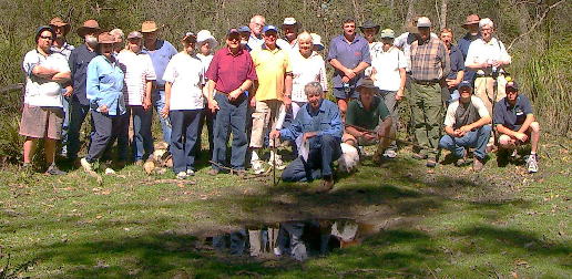
Out front myself, from left persons 3 and 4 Gwenda and Arthur Marsh,
persons 6 and 7 Russell and Wendy Walker of Tolmie.
persons 8 &10- Sally and Ben Dykstra.....
 Kelly
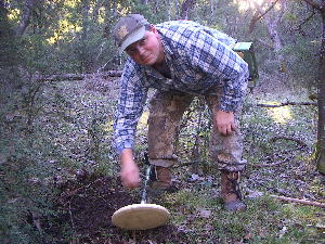
researcher Tim Smith pictured,
Kelly
researcher Tim Smith pictured,
used his instrument to locate the site.
Here Tim detects for bullet lead at Kellys Creek .
Copyright ,, no text or images may be reproduced without
written permission from the author Bill Denheld.
The back
ground image is of Kelly camp circa 1883