

Police journey to Stringybark
Ck Oct 1878 -
did the police party get lost?
Bill Denheld
Clues come from
evidence by Ned Kelly and Thomas McIntyre - sole survivor of the shootout
with the Kelly Gang.
The
map below sets out to plot the possible route the police party took in
getting to Stringybark Creek 25 October 1878. More out of interest
than anything else , we find contradiction in both Thomas McIntyre's
version and that of Ned Kelly. Ned's version is best supported by
historical documents that Ian Jones used to describe the route in his book
, Ned Kelly; A Short Life.
McIntyre described the journey in simple terms but with gaps in his
' The Manuscript of Thomas McIntyre -The sole survivor of the Massacre of
Police at Stringybark Creek.'
It is important to note the map below does not show current roads or
tracks. In those days there were only large leases called Runs, - we only show these
and main streams as mentioned in the texts. Ewen Tolmie owned Dueran
and Hollands Ck runs, some 56.000 acres marked in yellow. These were adjoining another very
large lease called Fern Hills on which Stringybark Creek and Bullock
Creek ( later Kellys Ck is
situated.
It is my belief that Fern Hills lease forms the bulk of country
known as 'Tablelands'
Hollands Ck Run was also a flat tableland but at a
lower level.
The map
is drawn to scale from Australian Nat.Map sheet 8123 and 8124.
The leases shown are an overlay traced from a book 'Victorian Squatters'
Robert Spreadborough and Hugh Anderson. Much care is taken for accuracy
although I stand to be corrected. Bill Denheld
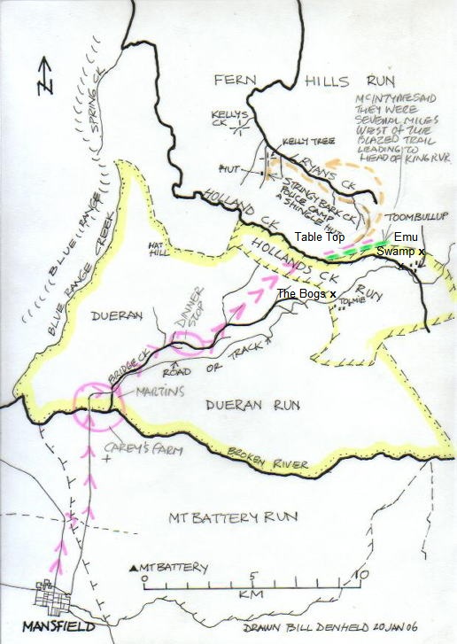
The pink arrows follow McIntyre's
description, except that he states they went in a straight line from their dinner stop to Stringybark Ck.
This straight line I have not dotted in to avoid confusion because by his
topographic descriptions they ended up at the head waters of Ryans Ck,
near where Ned said he found a second set of tracks ?.
The
green dotted line
marks a possible
blazed line of trees marking the edge of the Hollands Creek Run adjoining
Fern Hills. Was this the blazed trail referred to when
McIntyre wrote- " Seeing that we were
several miles to the west of the blazed line leading to the head of the
King river "
Follow this green line direction and you end up at the head waters of the King river only a few
miles east, ( to the right of the picture above)
If McIntyre refers to a line of blazed trees We can be sure Kennedy was shown or told of a blazed trail
for boundary marking. McIntyre did say the blazed trees started on the otherside of Hollands Creek only.
It is not co-incidence that the green line follows the a boundary not defined by
a stream. In Mc's statement above 'blazed line
leading to the headwaters of the King river indicates they were travelling
to the area I have marked in green on the map because elsewhere the lease boundaries were Creeks,
Rivers or water courses.
Ned Kelly wrote in his "Cameron letter' explaining
" I
came across tracks of Police horses between tabletop and the bogs I
crossed them and went to Emu Swamp and returned home, I came across more
Police tracks making for our camp"
This is proof enough to suggest the police were in fact not
"several miles to the west of the blazed line leading to the head of the
King river "
, rather right near and between Table Top and the Bogs as Ned
had said where he saw police horse tracks which he thought were those of
the other police party coming from Benalla, but this was not the case as
the two parties never met up.
The orange dotted line refers to Ian
Jones's book and Ned's version -
This explains why when the police returned to Stringybark Ck that first
day, they came back from the North. It is my theory that had the police
arrived at S/bark from the South, no one would try and escape in a
northerly direction unless you were familiar with the terrain.
From Ian's book page 114 2003 edition
" Ned found the tracks of four mounts and a
packhorse - shod with Govt. issue shoes leading across the hollows
towards Hollands Ck and Toombullup.
That evening Ned rode back up the Eastern end of Toombullup Ridge near
Lofty Emu swamp and struck west towards Bullock Creek.
He came across more tracks of Police horses, suggesting that a second,
south bound party had looped around the head waters of Ryans Creek.
They were heading down towards some old gold workings near a derelict
Shingle hut on Stringybark Creek "
Ned's version suggests the police party got lost, as they ended up
near at the
headwaters of Ryans Ck and worked their way back west along it till they found
Stringybark Creek, the Shingle hut, and the place to make camp.
McIntyre- in his memoirs, We (police) left 5 am 25th Oct and arrived at Stringybark Ck by 2 pm. On the way they had dinner
and camped along Bridge Creek. The distance as the crow flies is only 22 Km. Add to
this the rugged country and slowness of the journey, we can double the
distance to travel. Say 50 Km or 30 Miles. Not counting their stop over
time, they travelled at about 5 Km per hour.
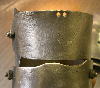
It is interesting to note that McIntyre produced three statements as
witness evidence against Ned Kelly. On one 'deposition' dated 15 Oct 1880
shows a small hut drawing. Who drew the hut is not known, but the text in
blue is hand written most probably by McIntyre himself. On the margin is
an index of other peoples names within the document.
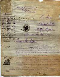
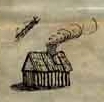
Was this hut drawing to represent the Shingle hut at Stringybark Creek?
The front page reads-
The ------ ,
Edward Kelly
Willful murder of Thomas Lonigan
Brief for the Prosecution
Thomas McIntyre,
Image courtesy of PROV the Public Records Office Victoria . McIntyre's
deposition. Citation files could not be found - to be announced.
Copy right 22
January 2006
Dueran Station
looking towards Blue Range. The gentleman in the cart is thought to be
Ewan Tolmie. photo private collection.
The location of this photo can be fixed on the hand drawn map above where
it says Dueran.
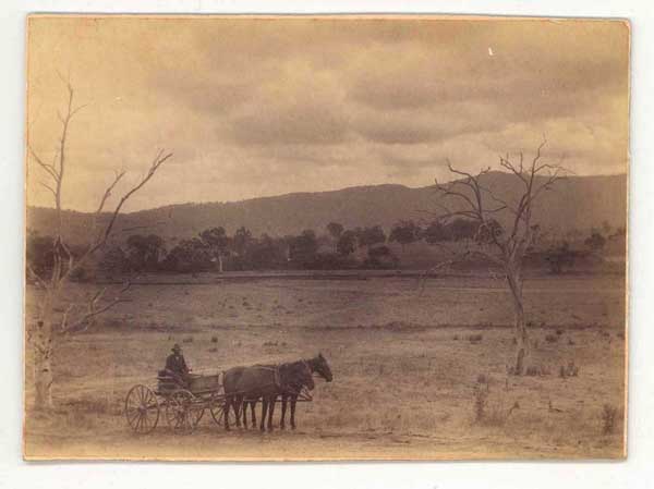
The inscription on the back of the 1883 photo reads - Dueran flat and Blue
range
Copyright ,, no text or images may be reproduced without
written permission from the author Bill Denheld. Copyright
Contact bill at denheldid dot com
direct for
feedback or
comment.
Amended July 2013 to clarify where the Bogs and Table Top country and
Emu Swamp are located on the map, and additional text from Ned Kelly
Cameron letter.